


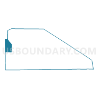
Voting District 1410640000001, Presque Isle County, Michigan
About
Outline

Summary
| Unique Area Identifier | 599308 |
| Name | Voting District 1410640000001 |
| County | Presque Isle County |
| State | Michigan |
| Area (square miles) | 63.59 |
| Land Area (square miles) | 61.45 |
| Water Area (square miles) | 2.14 |
| % of Land Area | 96.63 |
| % of Water Area | 3.37 |
| Latitude of the Internal Point | 45.52722870 |
| Longtitude of the Internal Point | -84.19637840 |
Maps

Graphs
Select a template below for downloading or customizing gragh for Voting District 1410640000001, Presque Isle County, Michigan


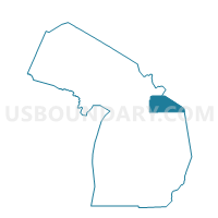
Neighbors
Neighoring Voting District (by Name) Neighboring Voting District on the Map
- Voting District 0310742000001, Cheboygan County, MI
- Voting District 0313420000001, Cheboygan County, MI
- Voting District 0318476000001, Cheboygan County, MI
- Voting District 1415794000001, Presque Isle County, MI
- Voting District 1416016000001, Presque Isle County, MI
- Voting Districts not defined, Presque Isle County, MI
- Voting Districts not defined, Cheboygan County, MI
Top 10 Neighboring County Subdivision (by Population) Neighboring County Subdivision on the Map
- Benton township, Cheboygan County, MI (3,206)
- Grant township, Cheboygan County, MI (846)
- Ocqueoc township, Presque Isle County, MI (655)
- North Allis township, Presque Isle County, MI (521)
- Waverly township, Cheboygan County, MI (457)
- Bearinger township, Presque Isle County, MI (369)
- County subdivisions not defined, Presque Isle County, MI (0)
- County subdivisions not defined, Cheboygan County, MI (0)
Top 10 Neighboring Unified School District (by Population) Neighboring Unified School District on the Map
- Cheboygan Area Schools, MI (14,220)
- Onaway Area Community School District, MI (5,778)
- School District Not Defined (Water), MI (243)